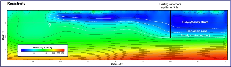

Resistivity surveys are an excellent tool to detect variations in soil and rock resistivities and have the ability to detect features from shallow to a great depth. In near-surface, geotechnical applications, anomalous resistivities mainly originate from pore media, eg. electrolytes and/or clay, and not from the solid material, rocks and gravel, as they are comparatively too resistive; the results are measures of soil moisture and clay/weathering.
The Resistivity / Induced Polarisation (Res/IP) combination surveys are well established for mapping disseminated sulphides commonly associated with gold mineralisations. Fully integrated Electric Resistivity Imaging (ERI) equipment capable of Res/IP are becoming increasingly popular due to their lower cost and portability. With continual improvement in output power and detection limits these instruments have the ability to map chargeabilities and resistivities to depths in excess of 100m.
Resistivity measurements
The resistivity method is based on measuring the potential between one electrode pair while transmitting a current between another electrode pair. The depth of influence is proportional to the separation between the electrodes and varying the electrode separation provides information about the stratification of the ground. The measured quantity is called apparent resistivity. Apparent resistivity data must be ‘converted’ to a resistivity distribution before they can be interpreted. The process of converting the data is a computer-based inversion and the outcome of that process is a model of distribution of resistivity in the ground.
Induced Polarisation measurements
While the resistivity method provides information about the electrical resistive properties of the subsurface, the Induced Polarisation (IP) method targets the capacitive characteristics of subsurface materials. When the current is switched off in resistivity measurements, the voltage does not instantly return to zero, but decays over time. This overvoltage effect or chargeability is recorded, allowing some inference of the polarisation properties of the subsurface.
The IP effect is caused by two main mechanisms, the membrane polarisation and the electrode polarisation effects. The membrane polarisation effect is largely caused by clay minerals present in the rock or sediment and is relevant in engineering and environmental surveys. The electrode polarisation effect is caused by conductive minerals in rocks as the current flow is partly electrolytic (through groundwater) and partly electronic (through the conductive mineral). This effect is of interest in surveys for metallic minerals, such as disseminated sulphides (commonly hosting gold).
|
A few examples of Geotechnical applications: |
A few examples of applications in mineral exploration: |
|
• Mapping contamination in groundwater |
• Mapping disseminated sulphides |